Are maps art?
Maps can indeed be considered works of art, particularly when they are crafted with intricate details and aesthetic appeal. Cartographic elements such as typography, illustration, and colour schemes can contribute to the artistic value of a map. Historical maps or those featuring unique design styles may be admired for their artistic merit, transcending their utilitarian purpose. Throughout history, maps have been appreciated not only for their navigational function but also for their beauty and creativity.
Maps and Time: Recording Humanity’s Story
Maps provide a visual representation of our world, capturing not only geographical features but also the essence of human civilization and the temporal context in which they are created. Through cartographic artistry, maps record the evolving narratives of societies, reflecting their beliefs, knowledge, and technological advancements. Each map becomes a time capsule, encapsulating the collective identity and aspirations of its creators. Beyond their navigational utility, maps stand as artistic testimonies to the ever-changing tapestry of human existence, documenting our history and the spirit of our time.
From ancient parchment scrolls to modern digital renderings, maps bear witness to the progression of our understanding and the multiplicity of cultures that have shaped our planet. They serve as invaluable records of our collective identity, offering a glimpse into the rich tapestry of human experience throughout the ages.
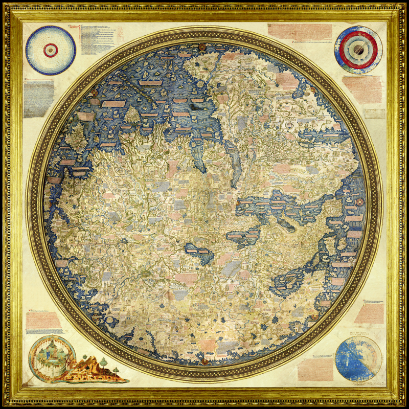
The Fra Mauro Mappa Mundi

The Fra Mauro map stands as a testament to the Renaissance era’s advancements in geographical understanding.
Created by the Italian cartographer and monk Fra Mauro (1400-1464), Mappa Mundi is one of the most significant pre-modern world maps. Renowned for its precision and detailed representation of geographical knowledge at the time, Fra Mauro’s map stands as a testament to the era’s advancements in geographical understanding. This work is a significant example of the blending of cartography, art, and scientific inquiry, reflecting the Renaissance period’s cultural and historical significance.
When we consider maps an art form, our perspective on them broadens.. Viewing maps through an artistic lens encourages us to appreciate their aesthetic qualities, intricacies, and cultural significance. Instead of solely ascertaining geographical information, we recognize maps as creative expressions that reflect the historical, societal, and individual contexts in which they were crafted.
This expanded viewpoint enriches our understanding of maps, highlighting their ability to capture the human experience and offering insights into the cultural and historical narratives of different eras.
Recognizing maps as art can elevate their value beyond their utilitarian purpose, prompting us to preserve and celebrate them as valuable cultural artifacts.

Hi Rebecca, I find maps very interesting. Gregory has a few books full of maps of various historical battles. My mom likes to draw maps from books she read like Tolkien.
LikeLiked by 1 person
I share your mother’s love for the LOTR maps, Robbie. With those maps, I was able to delve deeper into the world created by J.R.R. Tolkien. I found that the maps provided me with a visual representation of the various locations and journeys undertaken by the characters, adding another layer of immersion to the already rich narrative of the books and movies. With those maps, Gregory will have a much better understanding of what happened in pivotal historical events.
LikeLike
Hi Rebecca, yes, maps do open doors – smile!
LikeLiked by 1 person
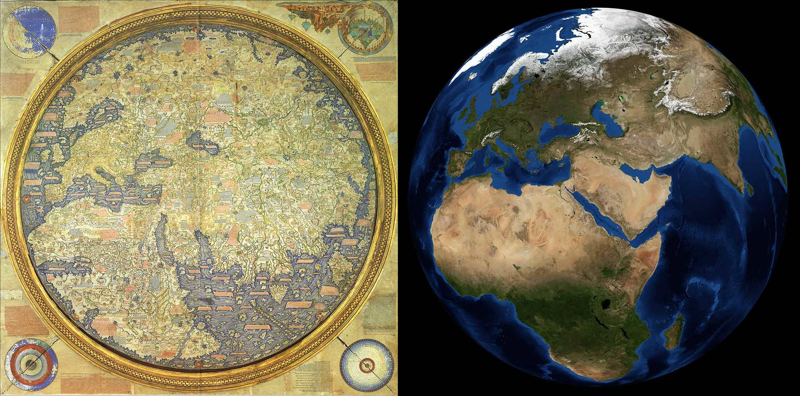
I thought I recognized an upside down Italy.
That is a spectacular map. Wow. What a treat to see what the world looked like pre Christopher Columbus.
Marco Polo’s original book/writings, gone forever? Or hidden(hoarded) forever? I wonder this about other coveted objects of art from the past.
Great post, Rebecca, thank you!
Yes, 100 % that map is art. Google maps are not art.
LikeLiked by 1 person
A very interesting point, Resa. I think it goes to our definition of art. I had the same thought when I was looking at a map of Vancouver Skytrain routes. So, the question I asked: What is the definition of Cartography? So I did some research when I was creating this post. I wanted to add more on these lines but thought that it would take away from the Mappa Mundi discussion. Here is what I found:
Cartography is widely recognized as both a science and an art form today. While its primary function is to accurately represent geographical information, cartographers often incorporate elements of design, creativity, and aesthetics into their maps. The combination of technical precision with artistic expression has elevated cartography to a form of visual storytelling that is appreciated for its beauty and functionality across various fields such as geography, urban planning, and environmental studies. The intricate balance between accuracy and visual appeal in modern cartography continues to blur the lines between science and art, making it a dynamic and evolving discipline in today’s digital age.
By the way, you will find this interesting: Tolkien’s cartography of Middle Earth is renowned as the most printed guide to a non-existent place ever. Each of these maps has its own fascinating story, intricately detailing the lands, regions, and paths traveled by the characters in his epic tales.
https://guides.library.ubc.ca/historicalmaps/supporting-your-research
LikeLike
Thank you for providing a different perspective on maps! The video provides a fascinating look at how the premier medieval map was created.
LikeLiked by 1 person
When I was researching this post, I thought of the GPS that we use on a daily basis and all of the technological advances that have been made since medieval times. Think air tags and tracking mechanisms. Consider that in the Middle Ages, maps were often hand-drawn on vellum or parchment, lacking accurate scales or standardized symbols. Cartographers relied on landmarks and estimated distances. Today, advancements in technology have revolutionized mapmaking with the use of satellite imagery, Geographic Information Systems (GIS), and digital mapping tools. These modern techniques allow for precise measurements, detailed representations, and interactive maps that can be accessed and updated in real-time.
It seems that we need to know our location in relation to our surroundings. It is not enough to know that we are standing in a particular point. Animals, on the other hand possess a remarkable ability to navigate their surroundings without the use of maps. I have often wondered if we are the most advanced creatures that inhabit the earth!!!
LikeLiked by 1 person
You’re right that animals seem to have an internal navigation system that humans lack.
LikeLiked by 1 person
I love maps! When I was a child, I wanted to become a cartographer! Of course, this was in amongst a long list of childhood endeavors. LOL!
LikeLiked by 1 person
I am delighted that you enjoyed this post, Colleen. I am not surprised that you wanted to be a cartographer! I believe that cartographers and poets share a common passion for capturing and representing the world around them. While cartographers meticulously map out geographical features with precision and accuracy, poets use words to paint vivid images and evoke emotions. Whether it’s through maps or verses, cartographers and poets strive to convey the beauty and complexity of the world in their creative endeavours.
LikeLiked by 1 person
You’re so lovely Rebecca. It’s the surrounding beauty that makes our lives so worth living! Maps are almost obsolete now with GPS. I still love them.
LikeLiked by 1 person
I share your love of maps, Colleen. I have a huge medieval map in my living room. Every time I pass by, I imagine traveling back to a past time. Isn’t it fun to travel in place. No jet lag! LOL!
LikeLiked by 1 person
I would love a medieval map! That is magical, Rebecca. I can imagine your travels. No jet lag!! LOL!
LikeLiked by 1 person
That Fra Mauro map is indeed a beautiful work of art, Rebecca! Excellent post!
LikeLiked by 1 person
I am so pleased that you enjoyed this post, Dave! How Fra Maura was able to create a relatively accurate map was remarkable. I believe that our fascination with map stems from a fundamental human need to comprehend and navigate the world we inhabit. Now we are focused on space. I wonder how the next century will view our efforts to understand the universe.
LikeLiked by 1 person
Rebecca, I agree. Those old maps are a wondrous blend of science and art. It must have been amazing to live during times when everything (even something as utilitarian as a map) was made with beauty as much in mind as utility. You surprised me with this subject — a great idea for a post. Hugs on the wing.
LikeLiked by 1 person
I am delighted you enjoyed this post. I was thinking back to Covid when travel was curtailed and this question came to me: “Why are maps important even when we no longer travel? So I did a little some research – here’s what I found:
Maps are essential beyond just navigation during travel or their artistry. They provide valuable information about geographical features, land use, and infrastructure. Maps help in urban planning, disaster management, and environmental conservation. They are crucial for understanding demographics, cultural diversity, and historical trends. Maps also play a significant role in education, research, and business development. Overall, maps are indispensable tools for gaining insights into the world around us, even when we are not physically traveling.
So, you may ask, why I asked this question. A couple of days ago, Calgary Alberta had a catastrophic event. A major feeder water main break near the western edge of the city plunged Calgary’s water supply into a critical state Wednesday night. Every one had to cut their water usage or there was a real danger of running out of water. YIKES!!! Today, news reports indicated it would be a minimum 5 – 7 days before the situation would be resolved.
The issue was – they couldn’t find the source of the breakage. I can only imagine all the engineers poring over the city maps to determine the source.
https://www.cbc.ca/amp/1.7229324
LikeLike